Franz Kröger
The Bulsa and Their Political Units
After the German Nazi dictatorship was defeated in 1945, it became necessary to create a new constitutional state. Three of the Allied forces (USA, Britain and France) had clear ideas about how the new German state should be organized. It would be democratic and federalist, and human rights would be included in the new constitution. The Allies made important stipulations; for example, the boundaries of the occupation zones had to remain in place. After the new German federation came into force, the German Luther Committee examined the federal structure to make improvements and determine which characteristics should be used to define the individual regions of the federation. Some of their proposals will be analyzed here for their applicability to African conditions, especially those of the Bulsa.
1) The ethnic affinity of the inhabitants, that is, their affiliation to ethnic units such as Bavaria, Swabia, and Westphalia, should be taken into account.
In the German constitution of 1919, these units were still referred to as tribes (Stämme). Although this name was certainly not quite appropriate, there were some similarities to tribes in the African sense.
The Bulsa were fortunate that in most political divisions of the past, tribal affiliation was strongly respected, even if the tribal area was initially only part of a larger whole. Kasena and Dagara were divided early between two different European colonial powers, which later became Ghana and Burkina Faso. The inclusion of the Bulsa in the Navrongo District (until 1974) later aroused the resentment of many young Bulsa, some of whom had organized themselves into the Bulsa Youth Association.
2) The historical and cultural connections should be considered. Before being conquered by the British colonial powers, the Bulsa region was culturally, religiously and linguistically united. Tribal consciousness may not have been particularly strong in the early period, but it was consolidated by historical events such as the defeat of Babatu at the end of the 19th century.
3) Another important factor in the creation of political units is their size. One advantage of having smaller units is that the individual citizen can be better involved in the political process. In elections, they may often know the candidates personally, and they can more easily put forward their personal wishes, for example, when a project is being implemented. Journeys to the authorities are shorter and therefore more eco-friendly.
The main advantage of large political or administrative units is that the administrative costs are lower than for two areas created by division.
4) According to the German Luther Committee, another aspect that should be taken into account is economic expediency. For example, in post-war Germany, two ethnic groups [German Constitution: Landsmannschaften] that were very different in their attitude to life and temperament, namely the fun-loving Rhinelanders and the sober, less humorous Westphalians, were merged into one large federal state (North Rhine-Westphalia) because the Ruhr region, Germany’s most important industrial area, should not be divided between two federal states.
—
Economic expediency has not played a major role in the ethnic areas of the Bulsa and those of their neighbors because there are no significant mineral resources or important industrial areas here.
The desirable characteristics listed above for the creation of political-administrative units appear to be only partially suitable for the conditions in Ghana.
In his essay “The Regional Boundaries of Ghana,” Bening (1973: 50-51) details the characteristics that have been considered in Ghana and the Gold Coast:
…population and ethnic distribution, as well as traditional allegiances and the need for convenience of administration [should be considered]…
Some regions were created in response to the expressed wishes and agitations of the people while others are the outcome of unsolicited and direct government action.
…the truncation of traditional states by regional boundaries was avoided…care should be taken to avoid creating a multiplicity of small regions…
At first glance, the practical implementation of the division of northern Ghana into political-administrative units appears to be a division of a large, unorganized country that in part was even unknown to those in power.
1) The North before 1901
Even before the creation of the protectorate “Northern Territories,” the Ashanti hinterland was divided into three large districts: the Kintampo District, the Black Volta District, with the capital Wa and the White Volta District, with the capital Gambaga (Bening 1975: 648). The White Volta District was divided into the subdistricts of Daboya, Mamprusi (containing the capital, Gambaga) and the Frafra subdistrict, with the headquarters in Balungo. The latter also included Bulsaland, of which only the village of Kanjaga is shown on Bening’s maps (1975: 648, map 1898).
2) The Northern Territories of the Gold Coast, a British Protectorate (1901–1957)
The protectorate was administered by a chief commissioner (CCNT) residing in Gambaga (Wikipedia: Northern Territories of the Gold Coast).
On October 15, 1905 (Bening 1975: 652), a new unit was created with Navrongo as its capital. The eastern parts of this subdistrict were later amalgamated into a separate district, while Bulsaland remained part of Navrongo District until 1974.
In approximately 1910, CCNT Captain Armitage subordinated Chuchuliga to Navrongo, but in 1923 Chuchuliga fell again to Bulsa (cf. also Francis Afoko 1970: 13).
3) Provinces
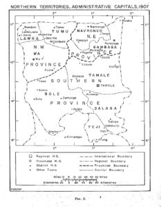
In 1907, the administrative boundaries were reorganized under CCNT Armitage (Bening 1975: 653-654). Three provinces were created, the Southern Province with the capital Tamale, the N.W. Province with the capital Wa, and the N.E. Province with the capital Gambaga, including Navrongo (with the Bulsa area) and Gambaga districts. According to Bening, the reasons for the reorganization were no longer military, as was the case with earlier territorial reforms (for example in 1901), but economic (the locations were chosen in relation to trade routes, the existence of large markets, etc.).

Provinces 1907, Source: Bening 1975: 654
4) The Bulsa and Mampurugu
Even before 1911, the Nayiri (king or paramount chief of the Mamprusi) had claimed jurisdiction over the Frafra, Kusasi, Gurunsi and Bulsa (Iliasu 1975: 5): “Northcott [CCNT] reported in 1898 that the reigning Nayiri, Na Barega, lay claim to these districts as well as all territory as far west as Leo” (Iliasu 1975: 6 and 26, fn 10).
In 1911, Armitage established the North-Eastern Province as the Mamprusi kingdom with the subdivisions Mampurugu, Kusasi, Frafra, Gurunsi and Bulsa. Each of them was to be administered by a head chief (Iliasu 1975: 7), but his election was only carried out for the Gurunsi (Navron-Pio) and Bulsa. The election of the Bulsa head-chief in 1911, who was called paramount chief from the beginning by the Bulsa, was described by Iliasu (1975: 7). The Sandemnab was elected by the chiefs of Wiaga, Siniensi and Kadema, the Kanjaga’s single vote came from Fumbisi, while Doninga; Yiwasi and Bachonsa abstained.
According to Armitage, in the beginning, the association of the Bulsa and Gurunsi with Mampurugi appeared to have met with some approval (Iliasu 1975: 11), and the Nayiri even considered a staggered tribute, which for the Bulsa was to consist of four cows a year. This demand for tribute could not be justified according to Iliasu. I (F.K.) do not know whether and for how long this tribute was paid or whether the customary presents (cattle and gowns) that a newly elected chief made and for which he received a red fez in return, were regarded as part of this tribute. In May 1912, an “unusual meeting” (Iliasu, p. 11) took place at Nalerigu. It was attended by the representatives of Sandema, Doninga, Fumbisi, Siniensi, Wiaga and others. According to Iliasu, “That meeting had aroused fears of Mamprusi domination among the Builsa and Gurunsi” (1975: 13). They suspected that the Mamprusi tried to gain firmer control over their enlarged kingdom, and they did all they could to oppose the Armitage system (ibid.).
In the colonial government (in Accra), there also existed “some grave doubts about the efficiency of the existing [Armitage’s] scheme of local administration [in the Northern Territories]” (Iliasu 1975: 19). Concerning the Bulsa and Gurunsi, CCNT Jackson remarked “It was an arbitrary act, unsupported by historical facts” (quoted from Iliasu 1975: 23). Iliasu reports that “The Builsa and Gurunsi…refused the subordinate position to which they had been reduced since 1911” (ibid, p. 223).
The political and administrative ties between the Bulsa and Mampurugu came to an end when, after dividing the Northern Territories in 1960, the Mamprusi Empire was allocated to the Northern Region and the Bulsa and Gurunsi territories to the Upper Region (Bening 1973: 48).
5) The Upper East Region (Since 1960)
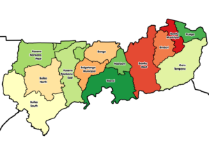
The Northern Territories, which had been enlarged in 1957 by including part of the former Togo Mandate, were divided on July 1, 1960 into the Northern Region, with its capital Tamale, and the Upper Region, with its capital Bolgatanga.
The two newly created regions were quite different in size, but their populations had similar numbers (Iliasu 1975: 48) as the extreme north of Ghana is more densely populated than the centre.

The Upper East Region (since 1960), Source: Wikipedia (English) : Upper East Region
6) The Bulsa District and Its Division into Bulsa North and Bulsa South
Even after the separation of the Navrongo District from Mamprugu, Bulsaland remained a part of the Navrongo District.
On September 1, 1934, “The Sandemnab and his Council became the Native Authority in the Bulsa area” (Akankyalabey 1984: 58). In 1951, the native authorities were replaced by District Local Councils (Ibid. p. 59). They were responsible for schools, water, health and roads. It was only in 1974 that Bulsaland became an independent district.
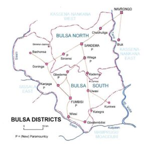
Even before the division of this district, the area was divided into two constituencies in parliamentary elections, which largely corresponded to the later division into Bulsa North and Bulsa North. The division was completed on June 28, 2012 when Fumbisi became the capital of Bulsa South and Sandema the capital of Bulsa North.
Although the Bulsa feel that they are a community bound together by history (for example by their common defense against the slave raider Babatu), their common language Buli, religion and social structure, there are still factors that distinguish the two parts from each other. Most of the North Bulsa (except Chuchuliga) derive their descent from Atuga, who migrated from Mamprusiland around 1800, while the Southern Bulsa are either endogenous or have their own history of origin.
There are small differences between the dialects of the North and South Bulsa, but these in no way impede communication. How far smaller differences exist in other cultural areas, for example in religion, social structure or economy, still needs to be investigated, but they are probably also insignificant.
The reaction of the Bulsa to the division of their tribal area was mixed, and even among the South Bulsa there was considerable criticism as well as approval, as the following quotes from the social media groups show:
• Let us hope this will enhance development in Buluk.
• I am from Bulsa South, but as a matter of fact, this [new district] is not necessary. Another new luxury house for a DCE, cars to drive about, offices with people sitting and playing lotto and, and… I think we need to remain a united Buluk and push for real development.
• I’m afraid the new district is yet another bureaucratic bottleneck, a diversion from the real need!
• This will certainly bring development to the Builsa district.
For several years (2012–2018), both Bulsa districts had the same political status. In December 2018, President Akufo-Addo announced the elevation of Builsa North to a municipality after he had signed an executive instrument to that effect at Sandema, the municipal capital (Ghanaweb, December 23, 2018). The first MCE (municipal chief executive) was Madam Vida Akantagrim Anaab. In October 2021, she was confirmed by all assembly members present.
7) Chieftaincies in the Builsa Districts
Apart from Kunkwa and Kategri, which broke away from Sandema under the Sandemnab Akansugaasa (1927–1931), and Biuk, which has been part of the Navrongo District until today, the Bulsa people had been united under one head since 1911, when the Sandemnab was elected paramount chief. In December 2018, some more Bulsa chiefs were nominated paramount chiefs, and many former subchiefs were made chiefs. Thus, according to Robert Asekabta, in Sandema alone 22 former subchiefs were elevated to the office of chief.

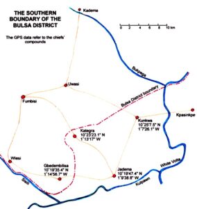
The southern boundaries of the Bulsa District, map drawn by F. Kröger
The new situation was described by Evans Atuick in January 2019 as follows:
The chiefs of Gbedema, Fumbisi, Kanjaga, Siniensi and Wiaga were granted paramountcy. Many former subchiefs were elevated to the rank of chief, with new subchiefs under them for assistance. The new chief of Wiaga-Sinyangsa, for example, has six subchiefs, namely those of Bachinsa, Badomsa, Goldem, Kubelinsa, Mutuensa and Sichaasa. There seem to be problems if the new chief’s section previously had no subsections, as is the case of Wiaga Longsa.

Map drawn by F. Kröger
References
Afoko, Francis Asianab
1970 The Ayietas. Private Notes by Francis Asianab Afoko. Copied by James Agalic with permission, November 1975. Transcribed by Rüdiger Schott, Bonn, April 2005. Further comments in footnotes by F. Kröger.
Akankyalabey, Pauline F.
1984 A History of the Builsa People. A dissertation presented to the Department of History, University of Ghana, Legon, as part of the requirements for the award of the B.A. degree.
Akanlig-Pare, George
2020 Palatalization in Central Buli. Legon Journal of Humanities, vol 31.2: 66-94.
Archives
Sandema Archive (in the Sandemnab’s palace)
Tamale Regional Archive (particularly: Register b: Navrongo)
National Archives of Ghana, Accra
Bening, R. Bagulo
1973 The Regional Boundaries of Ghana 1874-1972. Research Review, vol 9.1: 20-51.
Bening, R. Bagulo
1975 Location of District Administrative Capitals in the Northern Territories of the Gold Coast (1897-1951). Bulletin de l’I.F.A.N. 37, sér. B. no 3, pp. 646-666.
BULUK, Journal of Bulsa Culture and Society
1999-2022, no 1-14. https://buluk.de/new
Ghanaweb.com/Ghana Home Page/NewsArchive
Iliasu, A. A.
1975 The Establishment of British Administration in Mamprugu, 1898-1937. Transactions of the Historical Society of Ghana, 16,1:1-28.
Kröger, Franz
2012 Kunkwa, Kategra and Jadema: The Sandemnaab’s Lawsuit. Buluk – Journal of Bulsa Culture and History. No 6, p. 51-58.
Kröger, Franz
2013 Who was this Atuga? Facts and Theories on the Origin of the Bulsa. Buluk – Journal of Bulsa Culture and History. No 7, p. 69-88.
Kröger, Franz
2013 Colonial Officers and Bulsa Chiefs (with Special Consideration of Elections). Buluk – Journal of Bulsa Culture and History. No 7, p. 89-103 (Subchapter “The Paramountcy,” p. 100-103).
Kröger, Franz
2022 Die Bulsa Bildungselite als ethnologisches Forschungsobjekt. Diskussionen in einer Bulsa Facebook Gruppe. In: R. Hardenberg, Josephus Platenkamp, Thomas Widlok (eds.): Ethnologie als angewandte Wissenschaft. Das Zusammenspiel von Theorie und Praxis. Berlin: Reimer Verlag, p. 131-155.
Lentz, Carola
1998 Die Konstruktion von Ethnizität: Eine politische Geschichte Nord-West Ghanas, 1870-1990 (Studien zur Kulturkunde 112), Köln.
Population and Housing Census of Ghana
1960, 1970, 1984, 2000. 2010.
Verfassung des Deutschen Reichs (German Constitution 1919)
2019 Verlag der Reichdruckerei
Wikipedia
Northern Territories of the Gold Coast (retrieved July 2024)
Wikipedia
Upper East Region (retrieved July 24, 2024)
Williamson, Thora
2000 Gold Coast Diaries. Chronicles of Political Officers in West Africa. London and New York.
- Three Educated Bulsa Generations
- The Bulsa and their political units
- Teaching at Sandema Continuation Boarding School (1973 and 1974)
- Fiok/Feok and Similar Bulsa Festivals